 Southern Interior - Hwy 97 (Southern Interior Region)
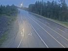
Hixon
Highway 97 at Swanson Road near Hixon, looking north.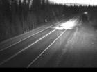
Hush Lake Road - N
Highway 97 about 25 km north of Quesnel near Hush Lake Road, looking north.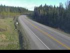
Hush Lake Road - S
Highway 97 about 25 km north of Quesnel near Hush Lake Road, looking south.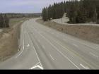
Dragon Lake - N
Highway 97 at Sales Road, about 10km south of Quesnel, looking north.
Dragon Lake - W
Highway 97 at Sales Road about 10 km south of Quesnel, looking west.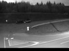
Dragon Lake - E
Highway 97 at Sales Road about 10 km south of Quesnel, looking east.
Dragon Lake - S
Highway 97 at Sales Road about 10 km south of Quesnel, looking south.
McLeese Lake - W
Highway 97 and Beaver Lake Road junction north of McLeese Lake, looking west.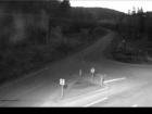
McLeese Lake - SE
Highway 97 and Beaver Lake Road junction north of McLeese Lake, looking southeast.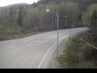
McLeese Lake - S
Highway 97 and Beaver Lake Road junction north of McLeese Lake, looking south.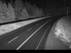
Bull Mountain - N
Highway 97 north of Williams Lake near the turn off to the Bull Mountain ski area, looking north.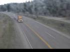
Bull Mountain - S
Highway 97 north of Williams Lake near the turn off to the Bull Mountain ski area, looking south,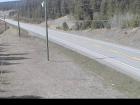
Enterprise - N
Highway 97 about 37 km south of Williams Lake, looking north.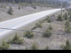
Enterprise - S
Highway 97 37 km south of Williams Lake, looking south.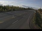
Begbie Summit
Highway 97 at Lookout Road near Begbie Summit about 21 km south of 100 Mile House, looking north.
Big Bar
Highway 97 about 8 km north of Clinton just before Big Bar rest area, looking north.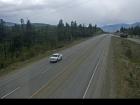
Monte Creek Brake Check - N
Highway 97 at the Monte Creek brake check, looking north.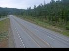
Monte Creek Brake Check - S
Highway 97 at the Monte Creek brake check, looking south.
Falkland
Highway 97 at Silvernails Road near Falkland, looking southeast.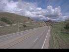
Kalamalka Lookout
Highway 97 at Vista Road turnoff south of Vernon, looking north.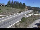
Lake Country - N
Highway 97 in Lake Country by Wood Lake, looking north.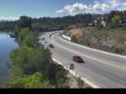
Lake Country - S
Highway 97 in Lake Country by Wood Lake, looking south.
Kelowna - N
Highway 97 at Highway 33 in Kelowna, looking north on Highway 97.
Kelowna - S
Highway 97 at Highway 33 in Kelowna, looking south on Highway 97.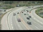
WR Bennett Bridge 02
WR Bennett Bridge west end, connecting Kelowna and West Kelowna, looking west.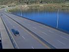
WR Bennett Bridge 04
WR Bennett Bridge mid-span, connecting Kelowna and West Kelowna, looking west.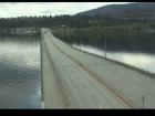
WR Bennett Bridge 07
WR Bennett Bridge east end, connecting Kelowna and West Kelowna, looking west.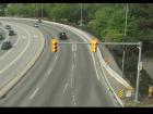
WR Bennett Bridge 11
WR Bennett Bridge east approach at Abbott Street, looking west along Highway 97.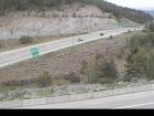
Highway 97 at Highway 97C - N
Highway 97 at Highway 97C junction about 5 km south of Westbank, looking north.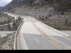
Highway 97 at Highway 97C - W
Highway 97 at Highway 97C junction about 5 km south of Westbank, looking west.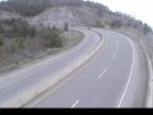
Highway 97 at Highway 97C - E
Highway 97 at Highway 97C junction about 5 km south of Westbank, looking east.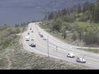
Highway 97 at Highway 97C - S
Highway 97 at Highway 97C junction about 5 km south of Westbank, looking south.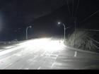
Callan Road
Highway 97 at Callan Road, about 6 km north of Summerland and 15 km south of Peachland, looking south.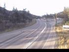
Kaleden - N
Highway 97 at Highway 3A junction just south of Kaleden Weigh Scale, looking north.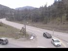
Kaleden - W
Highway 97 at Highway 3A junction just south of Kaleden Weigh Scale, looking west.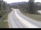
Kaleden - S
Highway 97 at Highway 3A junction just south of Kaleden Weigh Scale, looking south.


