 Southern Interior - Hwy 1 (Trans Canada Highway)
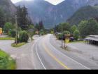
Yale - N
Highway 1 at Victoria Street in Yale, looking northbound.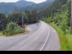
Yale - S
Highway 1 at Victoria Street in Yale, looking southbound.
Alexandra Bridge - N
Highway 1 at Alexandra Bridge, looking north.
Alexandra Bridge - S
Highway 1 at Alexandra Bridge, looking south.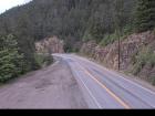
Hells Gate - N
Highway 1 about 3.5 km south of Hells Gate at Bradley Hill, looking north.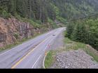
Hells Gate - S
Highway 1 about 3.5 km south of Hells Gate at Bradley Hill, looking south.
Boston Bar - N
Highway 1 about 12 km north of Boston Bar at Kahmoose Road in Boothroyd, looking north.
Boston Bar - S
Highway 1 about 12 km north of Boston Bar at Kahmoose Road in Boothroyd, looking south.
Jackass Mountain - N
Highway 1 between Boston Bar and Lytton at Jackass Mountain summit by CəX̣ʷ Cixʷ (Check-Chow) Bridge, looking north.
Jackass Mountain - S
Highway 1 between Boston Bar and Lytton at Jackass Mountain summit by CəX̣ʷ Cixʷ (Check-Chow) Bridge, looking south.
Gladwin - W
Highway 1 about 6 km east of Lytton Airport, looking west.
Gladwin - E
Highway 1 about 6 km east of Lytton Airport, looking east.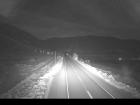
Spences Bridge
Highway 1 at the north end of Spences Bridge on the west side of the Thompson River, looking north.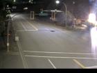
Cache Creek
Highway 1 at Collins Road, looking east on Highway 1/97.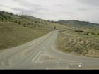
Savona
Highway 1 at Holloway Drive near Savona, looking west.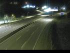
Dufferin - W
Highway 1 about 9 km west of Kamloops, looking west.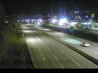
Dufferin - E
Highway 1 about 9 km west of Kamloops, looking east.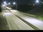
Kamloops - W
Highway 1 at Peterson Creek bridge in Kamloops, looking west.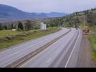
Kamloops - E
Highway 1 at Peterson Creek bridge in Kamloops, looking east.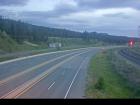
Miners Bluff - W
Highway 1 between Monte Creek and Pritchard, looking west.
Miners Bluff - E
Highway 1 between Monte Creek and Pritchard, looking east.
Squilax - W
Highway 1 east of Squilax Bridge, looking west.
Squilax - E
Highway 1 east of Squilax Bridge, looking east.
Sorrento - Blind Bay
Highway 1 at Highland Drive east of Sorrento at the Blind Bay turn off, looking southeast.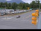
Salmon Arm - N
Highway 1 at 30 Street SW in Salmon Arm, looking north.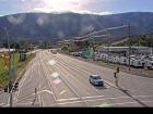
Salmon Arm - W
Highway 1 at 30 Street SW in Salmon Arm, looking west.
Salmon Arm - E
Highway 1 at 30 Street SW in Salmon Arm, looking east.
Salmon Arm - S
Highway 1 at 30 Street SW in Salmon Arm, looking south.
Annis Pit - W
Highway 1 about 8 km southwest of Sicamous at Annis Pit, looking west.
Annis Pit - E
Highway 1 about 8 km southwest of Sicamous at Annis Pit, looking east.
Sicamous - W
Highway 1 east of Sicamous at Cambie Road/Solsqua Road, looking west.
Sicamous - E
Highway 1 east of Sicamous at Cambie Road/Solsqua Road, looking east.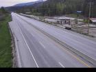
Perry River - W
Highway 1 about 30 km east of Sicamous near Perry River Bridge, looking west.
Perry River - E
Highway 1 about 30 km east of Sicamous near Perry River Bridge, looking east.
Eagle River - W
Highway 1 about 33 km west of Revelstoke, looking west.
Eagle River - E
Highway 1 about 33 km west of Revelstoke, looking east.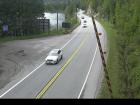
Griffin Lake - W
Highway 1 about 27 km west of Revelstoke by Griffin Lake, looking west.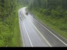
Griffin Lake - E
Highway 1 about 27 km west of Revelstoke by Griffin Lake, looking east.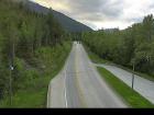
Three Valley Gap - W
Highway 1 about 20 km west of Revelstoke near Three Valley Gap, looking west.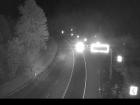
Three Valley Gap - E
Highway 1 about 20 km west of Revelstoke near Three Valley Gap, looking east.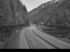
Clanwilliam Railway Overpass - W
Highway 1 about 14 km west of Revelstoke, looking west.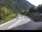
Clanwilliam Railway Overpass - E
Highway 1 about 14 km west of Revelstoke, looking east.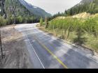
Boulder Hill - W
Highway 1 about 7 km west of Revelstoke, looking west.
Boulder Hill - E
Highway 1 about 7 km west of Revelstoke, looking east.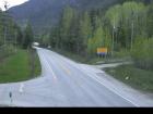
One-Mile Hill - W
Highway 1 about 4 km west of Revelstoke, looking west.
One-Mile Hill - E
Highway 1 about 4 km west of Revelstoke, looking east.
Hwy 1 at Hwy 23 - N
Highway 1 at Highway 23 in Revelstoke, looking north to Westside Road.
Hwy 1 at Hwy 23 - W
Highway 1 at Highway 23 in Revelstoke, looking west.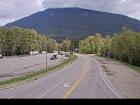
Hwy 1 at Hwy 23 - E
Highway 1 at Highway 23 in Revelstoke, looking east.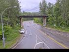
Hwy 1 at Hwy 23 - S
Highway 1 at Highway 23 in Revelstoke, looking south to Highway 23.
Revelstoke
Highway 1 at east end of Columbia River Bridge in Revelstoke, looking eastbound.
Albert Canyon
Highway 1 about 30 km east of Revelstoke, looking east.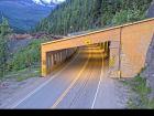
Jack McDonald Snowshed - W
Highway 1 about 46 km east of Revelstoke, looking west.
Jack McDonald Snowshed - E
Highway 1 about 46 km east of Revelstoke, looking east.
Rogers Pass
Highway 1 about 72 km east of Revelstoke at Rogers Pass in Glacier National Park, looking east.
Quartz Creek - W
Highway 1 about 40 km west of Golden near the Quartz Creek bridge, looking west.
Quartz Creek - E
Highway 1 about 40 km west of Golden on the Quartz Creek bridge, looking east.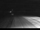
Donald Bridge - W
Highway 1 about 28 km north of Golden near Donald Bridge, looking west.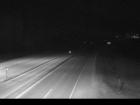
Donald Bridge - E
Highway 1 about 28 km north of Golden near Donald Bridge, looking east.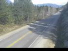
Blaeberry - NW
Highway 1 near Blaeberry River Bridge, looking northwest.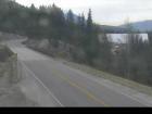
Blaeberry - SE
Highway 1 near Blaeberry River Bridge, looking southeast.
Golden northbound
Highway 1 at Highway 95 interchange, looking northbound along Highway 1.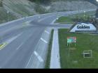
Golden eastbound
Highway 1 at Highway 95 interchange, looking eastbound along Highway 1.
Golden southbound
Highway 1 at Highway 95 interchange, looking southbound along Highway 95.
Kicking Horse Canyon
Highway 1 at 10 Mile Brake Check in Kicking Horse Canyon, looking east.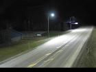
Field - SW
Highway 1 about 16 km west of BC/Alberta border at Field Access Road, looking southwest.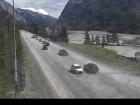
Field - NE
Highway 1 about 16 km west of BC/Alberta border at Field Access Road, looking northeast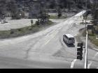
Field - SE
Highway 1 about 16 km west of BC/Alberta border at Field Access Road, looking southeast.
Lake Louise - W
Highway 1 west of Lake Louise Overpass in Alberta, looking west.
Lake Louise - E
Highway 1 west of Lake Louise Overpass in Alberta, looking east.
Castle Mountain - W
Highway 1 at Highway 93S junction, looking west.
Castle Mountain - E
Highway 1 at Highway 93S junction, looking east.
Castle Mountain - S
Highway 1 at Highway 93S junction, looking south.
Banff - W
Highway 1 east of Sunshine Ski Hill overpass in Alberta, looking west.
Banff - E
Highway 1 east of Sunshine Ski Hill, looking east.


